Our Services
Our product range contains a wide range of Layout Plot Marking, Total Station Surveyor, Bridge Surveyor, Building Surveyor and Boundary Surveyor

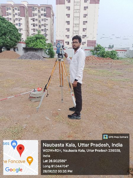
Total Station Surveyor – Precision Surveying with Advanced Instruments
A Total Station Surveyor is a professional who uses advanced electronic surveying instruments known as Total Stations to measure angles, distances, and elevations with high accuracy. These surveyors play a vital role in land development, construction, infrastructure projects, and property documentation by delivering precise survey data and digital maps.
The Total Station integrates electronic distance measurement (EDM), angle measurement, and data recording, allowing surveyors to collect field data quickly and accurately. A Total Station Surveyor can generate detailed topographic maps, 3D terrain models, and CAD-based layouts, which are crucial for engineering design and project execution.
Key Applications of Total Station Surveys:
Land & Property Surveys: Accurate boundary marking and legal documentation.
Construction Layouts: Aligning foundations, columns, roads, and utilities.
Topographic & Contour Mapping: Recording terrain levels for planning.
Infrastructure Projects: Supporting roads, bridges, railways, pipelines, and drainage systems.
Volume Calculations: Estimating earthwork for excavation and embankments.
Hiring a professional Total Station Surveyor ensures speed, accuracy, and efficiency compared to traditional survey methods. Their data eliminates manual errors, saves time, and provides precise inputs for architects, engineers, and developers. Total Station surveys are also widely accepted for government approvals, legal disputes, and land registration due to their reliability.


Road Surveyor – Precision Surveys for Road & Highway Projects
A Road Surveyor plays a key role in the planning, design, and construction of roads, highways, and expressways. Their primary responsibility is to conduct detailed surveys that provide accurate data on land levels, alignment, gradients, and terrain conditions, which is crucial for engineers and planners to design cost-effective, safe, and durable road networks.
Using advanced instruments such as Total Stations, GPS/DGPS, Auto Levels, Drones, and GIS Mapping, road surveyors collect precise measurements of the land. These surveys include topographic mapping, contour studies, cross-section, and longitudinal profiles, vital for road alignment and construction planning.
Key Tasks of a Road Surveyor:
Road surveyors work closely with civil engineers, contractors, and government authorities to deliver reliable data that supports both new road construction and maintenance projects, reducing errors, minimizing costs, and ensuring long-lasting infrastructure.

Layout Plot Marking – Accurate Land Division for Development Projects
Layout Plot Marking is a vital stage in land development, construction, and real estate projects. It involves the accurate division and marking of land into plots based on approved designs and legal documents. By using precise survey methods, layout plot marking ensures that each plot is properly aligned with roads, open spaces, utilities, and boundaries as per municipal or development authority guidelines.
Professional surveyors use Total Station, GPS/DGPS, Auto Level, and CAD software to mark plots with high accuracy. The process begins with detailed land measurement, followed by demarcation of roads, plot corners, and public spaces. Each plot is marked with permanent reference points or pegs, which serve as the foundation for future construction.
Key Benefits and Applications of Layout Plot Marking:
Accurate layout plot marking prevents boundary disputes, encroachments, and planning errors, making it a critical step in real estate development. It also helps developers showcase properly designed and approved layouts to potential buyers, increasing trust and property value.

Building Surveyor – Expert Inspection & Assessment for Safe Construction
A Building Surveyor specializes in the inspection, measurement, and assessment of buildings to ensure safety, compliance, and efficient use of space. They play a key role in onstruction, renovation, property evaluation, and legal documentation, providing expert advice to architects, engineers, developers, and property owners.
Their work includes building inspections, structural analysis, condition surveys, and design verification to ensure projects meet technical standards and government regulations Using modern tools like Total Station, Laser Scanners, Drones, and CAD/GIS software building surveyors prepare accurate plans, layouts, and reports** for planning and development.
Key Services of Building Surveyors:
Building surveyors also assist in dispute resolution, property valuation, and risk assessment, reducing construction errors, preventing legal issues, and ensuring projects meet safety and quality parameters.

Canal Surveyor – Expert Planning & Surveying for Water Management
A Canal Surveyor is a specialized professional responsible for surveying, mapping, and planning canals for irrigation, drainage, navigation, and water management projects. Canal surveys are critical for ensuring proper water flow, alignment, and capacity, directly impacting agricultural productivity, flood control, and sustainable water distribution**.
Using advanced instruments such as Total Station, DGPS, Auto Level, Drones, and GIS Mapping tools, canal surveyors collect precise data on ground levels, cross-sections, longitudinal profiles, and surrounding topography**. This information helps engineers design canals that are structurally sound, cost-effective, and environmentally sustainable**.
Key Services of a Canal Surveyor:
Canal surveyors work closely with government irrigation departments, construction companies, farmers’ cooperatives, and water resource engineers to ensure accurate planning and execution. Their surveys provide the technical foundation for new canal construction, repairs, and expansion projects.

Boundary Surveyor – Accurate Property Demarcation & Legal Compliance
A Boundary Surveyor specializes in identifying, marking, and documenting the exact legal boundaries of a property or land. Boundary surveys are essential for property ownership, real estate transactions, construction projects, land development, and dispute resolution. They provide clarity on property limits, ensuring transparency and legal compliance.
Using modern surveying instruments like Total Station, DGPS, Auto Level, and GIS Mapping boundary surveyors measure and map land with high precision. The process involves reviewing legal documents such as sale deeds, title records, and land registry maps, followed by field measurements to establish accurate property lines.
Key Services of a Boundary Surveyor:
Boundary surveys are crucial for residential, commercial, agricultural, and industrial properties, preventing encroachments and ownership conflicts. A professional surveyor provides official survey drawings and maps, which can be submitted to government authorities and courts if required.

Bridge Surveyor – Expert Surveying for Safe and Durable Bridges
A Bridge Surveyor is a specialized professional responsible for conducting surveys required for the planning, design, construction, and maintenance of bridges. Bridge surveyors ensure accurate measurement of terrain, riverbeds, valleys, and approach roads, providing the technical foundation for safe and durable bridge structures. Their role is vital in infrastructure projects where precision and compliance with engineering standards are critical.
Using modern instruments such as Total Station, DGPS, Auto Level, Drone Mapping, and GIS technology, bridge surveyors collect detailed data on ground levels, water flow, soil conditions, topography, and structural alignments. This information is used by engineers to prepare alignment drawings, contour maps, cross-sections, and 3D models for bridge design.
Key Responsibilities of a Bridge Surveyor:
Bridge surveyors work closely with civil engineers, architects, contractors, and government agencies to ensure projects meet technical, environmental, and safety standards. Their expertise is crucial for highways, railways, metro systems, flyovers, and pedestrian bridges.

Factory Layout – Efficient Industrial Planning
Factory Layout refers to the strategic planning and arrangement of machinery, equipment, storage areas, utilities, and workstations within an industrial site. The main purpose of an efficient factory layout is to ensure smooth workflow, safety, reduced production costs, and higher productivity. Proper layout design also optimizes space utilization, minimizes material handling, and helps industries meet operational and safety standards.
Professional factory layout planning is carried out using modern tools like CAD design, Total Station survey, GPS/DGPS, and GIS mapping, ensuring accuracy and compliance with industrial norms. The process involves studying site conditions, production processes, manpower requirements, and safety regulations, followed by creating a practical layout plan that balances efficiency and flexibility.
Key Benefits of a Factory Layout: