Our Services
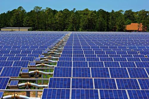
We offer the best product range of Electric Line Survey, Water Body Surveyor, Cross Sectional Survey and Solar Panel Survey.

Electric Line Survey – Accurate Planning for Power Transmission & Distribution
An Electric Line Survey is a specialized survey service carried out to design, plan, and implement overhead or underground electrical transmission and distribution lines. It plays a critical role in developing power infrastructure, ensuring accurate alignment, safety compliance, and cost-effective execution.
Using advanced surveying instruments such as Total Station, GPS/DGPS, Drone Mapping, and GIS technology, electric line surveyors provide precise data for engineers and utility companies.
The process involves route alignment, topographic mapping, and obstacle identification, helping determine the most feasible and economical path for electric lines. Surveys also ensure compliance with government regulations, safety standards, and environmental guidelines.
Key Applications of Electric Line Surveys:
Transmission Line Survey: Planning high-voltage transmission lines over long distances.
Distribution Line Survey: Designing low and medium-voltage lines for residential and industrial areas.
Underground Cable Survey: Mapping routes for safe cable installation with minimal disruption.
Tower & Pole Positioning: Identifying exact locations for towers, poles, and substations.
Right of Way (ROW) Surveys: Ensuring legal permissions and clearances for line installation.
Electric line surveyors work closely with power companies, government bodies, and contractors to deliver accurate survey data that supports reliable electricity supply and infrastructure growth. Their expertise ensures efficiency, reduces risks, and prevents costly rework.

Water Body Surveyor – Accurate Surveying & Mapping of Water Resources
A Water Body Surveyor specializes in surveying and mapping natural and man-made water bodies such as rivers, lakes, ponds, reservoirs, wetlands, and canals. These surveys are essential for water resource management, irrigation projects, flood control, aquaculture, urban planning, and environmental conservation. By providing accurate data on size, depth, boundaries, and storage capacity, water body surveyors help governments, developers, and communities make informed decisions about water usage and sustainability.
Using advanced technologies like DGPS, Total Station, Drones, Bathymetric Equipment, and GIS Mapping, surveyors capture precise measurements of water spread area, depth profiles, and surrounding topography. This data is further processed into digital maps, 3D models, and CAD drawings for planning, analysis, and legal documentation.
Key Services of a Water Body Surveyor:
Boundary Demarcation: Identifying legal limits of water bodies to prevent encroachment.
Hydrographic & Bathymetric Surveys: Measuring water depths and silt levels.
Capacity Estimation: Calculating storage potential for drinking water, irrigation, or industrial use.
Environmental Monitoring: Assessing siltation, water quality, and ecological balance.
Restoration Planning: Providing technical inputs for desilting, embankment strengthening, and conservation projects.