Our Product / Services
Leading Manufacturer, Supplier & Retailer of Sokkia iM-101 Total Station, Leica Flexline TS07 Total Station, Leica Flexline TS03 Total Station, Sokkia iM 55 Total Station and Vento Vt-02 Digital Theodolite.

Sokkia IM 101 Total Station – (Intelligent Measurement Total Station) incorporates all the features you need at a cost-efficient price. It will handle your most demanding survey layout or as-built project needs.
Tradition Meets Innovation
Key Features of Sokkia IM105 Reflectorless Total Station
With Sokkia IM-105 Total Station you get fast, accurate, and powerful EDM technology, best-in-class accuracy up to 6, 000 meter with a prism and up to 1000 meter in reflectorless mode, and a battery life of up to 28 hours. The iM-100 series intelligent measurement station is ready to be your hardest worker out in the field.
Construction and Survey Application Software Reliable All-Round Total Station
Cross-Sectional Survey
By using the MLM (Missing Line Measurement) program, the height difference between points can be calculated. Also, you can save time on reflectorless mode to measure a number of points of variation in a large area.
Stake Out
The Guide Light function will navigate the prism operator to move to the stake out line quickly so that stake out operation can be done effectively.
Elevation Stake
Staking out with 3D coordinates, eliminates the need to set up TS on the straight line for all elevation stakes.
Boundary and Cadastral Survey
By using the Area function, you can calculate the area easily. Also, you can determine the center point of the column such as electric pole, which cannot be directly measured, by using offset calculation.
Coordinate Measurement
With coordinate measurement, you can manage 3D coordinate data so that various calculations such as Road, Layout and more can be determined. 3D coordinate data management can improve the productivity drastically.
Topographic Survey
The trigger key, or measuring distance key, helps you perform topography quickly while continuously viewing through the telescope. Also, the long distance measuring range reduces the number of the instrument changes for more efficient working time.
Technical Specifications
| Model | iM115 Sokkia Total Station | |
|---|---|---|
| Telescope | ||
| Magnification / Resolving Power | 30x / 2.5″ | |
| Length | 171mm (6.7in.) | |
| Objective aperture | 45mm (48mm for EDM) | |
| Image | Erect | |
| Field of View | 1°30′ (26m / 1,000m) | |
| Minimum focus | 1.3m | |
| Reticle illumination | 5 brightness levels | |
| Angle Measurement | ||
| Display Resolution | 1″/5″ (0.0002 / 0.001gon, 0.005 / 0.02mil) | |
| Accuracy (ISO 17123-3:2001 | 1″ | |
| Dual Axis Compensator | Dual-axis liquid tilt sensor, working range: ±6′ | |
| Collimation Compensation | On/Off (selectable) | |
| Distance Measurement | ||
| Laser output (Reflectorless mode) | Class 3R / Prism / sheet mode: Class 1 | |
| Range reflectorless mode | 0.3 to 800m (2,620ft.) / Under good conditions*: 1,000m (3,280ft.) | |
| Reflective sheet | RS90N-K: 1.3 to 500m (4.3 to 1,640ft.), RS50N-K: 1.3 to 300m (4.3 to 980ft.), RS10N-K: 1.3 to 100m (4.3 to 320ft.) | |
| Mini Prism | 1.3 to 500m (4.3 to 1,640ft.) | |
| One Prism | 1.3 to 5,000m (4.3 to 16,400ft.) / Under good conditions* : 6,000m (19,680ft.) | |
| Display Resolution | Fine / Rapid : 0.0001m (0.001ft. / 1/16 in.) / 0.001m (0.005ft. / 1/8 in.) (selectable) Tracking / Road : 0.001m (0.005ft. / 1/8 in.) / 0.01m (0.02ft. / 1/2 in.) (selectable) | |
| Accuracy | Reflectorless: (2 + 2ppm x D) mm Reflective Sheet: (2 + 2ppm x D) mm Prism Mode: (1.5 + 2ppm x D) mm | |
| Measuring Time | ||
| Fine Measurement Mode | 0.9 sec.(Intial 1.5 sec.) | |
| Rapid Measurement Mode | 0.6 sec.(Intial 1.3 sec.) | |
| Tracking Measurement Mode | 0.4 sec.(Intial 1.3 sec.) | |
| OS, Interface and Data Management | ||
| Operating system | Linux | |
| Display / Keyboard | Graphic LCD, 192 x 80 dots, backlight, contrast adjustment / Alphanumeric keyboard / 28 keys with backlight | |
| Control panel location | On both faces | |
| Trigger key | Yes (right side) | |
| Data storage | Internal memory: Approx. 50,000 points Plug-in memory device: USB flash memory (max. 32GB) | |
| Interface | Serial RS-232C, USB2.0 (Type A for USB flash memory) | |
| Bluetooth® modem (option) | Bluetooth Class 1.5, Operating range: up to 10m | |
| General | ||
| Laser pointer | Coaxial red laser using EDM beam | |
| Guide light | Green LED (524nm) and Red LED (626nm), Operating range: 1.3 to 150m (4.3 to 490ft.) | |
| Levels Graphic | 6′ (Inner Circle) | |
| Circular Level | 10’/2mm | |
| Optical Plummet | Magnification: 3x Minimum focus: 0.5m from tribrach bottom | |
| Dust and water protection | IP66 (IEC 60529:2001) | |
| Operatig temperature | -4ºF to +122ºF (-20ºC to +50ºC) | |
| Size with handle (w x d x h mm) | 183(W)x 181(D)x 348(H)mm | |
| Weight with battery and tribrach | Approx. 5.3kg (11.7lb) | |
| Power Supply | ||
| Battery (BDC70) Detachable battery | Li-ion rechargeable battery | |
| Operating time (20ºC) BDC70 | Approx. 28 hours (single distance measurement every 30 seconds) | |

The Leica FlexLine TS07 high-quality, manual total station is based on a proven product concept that has been revolutionising the world of measurement and survey for nearly 200 years. The instrument is equipped with a comprehensive application-based software package – Leica FlexField software – that enables most survey and stakeout tasks to be carried out easily and efficiently. The new FlexLine manual total stations work reliably and deliver accurate results even in harsh environments.
Key Feature of Leica Flexline TS 07 Reflectorless Total Station
Leica FlexLine TS07 is a manual total station, enabling you to carry out mid- to high-accuracy survey and stakeout tasks easily and efficiently.
Building construction, civil engineering, or surveying and mapping professionals benefit from the Flexline TS07 helping them solve their daily professional challenges and tasks:
Leica FlexLine: The new generation of manual total stations
The new Leica FlexLine series is based on a proven product concept, revolutionising the world of measurement and survey for nearly 200 years. Unlike any other manual total stations in the market, Leica Geosystems manual total stations focus on providing the highest quality, the lowest total cost of ownership and the longest durability in the industry, enabling users to work with purpose-driven solutions for the best performance results.
AutoHeight: Revolutionising instrument height measurement
The Leica TS 07 offers the world’s first AutoHeight feature as an option. AutoHeight enables the instrument to automatically measure, read and set its instrument height. Prevent time consuming manual effort and eliminate critical errors during the instrument setup when this revolutionary feature uses a laser from the instrument to measure to the ground and automatically passes the measurement to the software.
Leica Flex Field software: Comprehensive, intuitive and easy to use
The Leica Flexline TS 07 Total Station is equipped with the Leica FlexField software, an intuitive, easy-to-use and familiar software. Guided workflows and easy to understand graphics and icons ensure a low learning curve when working in the field. The software makes the interpretation of measurement values or text no longer necessary and guarantees a faster and simple operation when you need it. With its pinpoint distance measurement system, you will be able to measure to both prisms and any surfaces.
The Leica FlexLine TS07 Reflectorless
Manual Total Station is high-quality surveying equipment that is used for efficient and convenient survey, stakeout, and area investigation applications. Offering a reflectorless range of up to 1, 640 feet (500 m) with the R500 EDM, this manual total station also measures a reflectorless range of up to 3, 280 feet (1, 000 m) with the R1000 EDM and range up to 11, 483 feet (3, 500 m) with a single prism. It also uses the Leica FlexField software which generates stable and accurate results in any environment.
This Leica FlexLine total station has a quadruple axis compensation which combines the Hz collimation and V-index correction. Equipped with a USB stick and SD card interface, this reflectorless total station accommodates an internal flash memory of 2GB and a 1GB SD RAM. Also, the TS07 also boasts WLAN (wireless local area network) and Bluetooth connectivity for easy on-site device communication. Plus, it uses a Laserclass 2 laser plummet and optional guide light for setting out.
The FlexLine TS07 Leica total station flaunts a 3.5-inch colored touchscreen LCD display with one illuminated keyboard. There is also an option of a second keyboard for more convenience. It features an IP66 rating which protects the instrument from dust and water. This total station uses exchangeable Li-ion batteries that power the device for up to 30 hours. In addition, the TS 07 total station can automatically measure, read, and set the instrument height with the optional AutoHeight feature to minimize errors and deliver a faster setup process.
Technical Specifications
| ANGULAR MEASUREMENT | |||
| Accuracy Hz and V | Absolute, continuous, diametrical | 1’’ / 2’’ / 3’’ / 5’’ / 7“ | |
| Display resolution: 0.1″ (0.1 mgon) Quadruple axis compensation Compensator setting accuracy: 0.5″’ / 1″/ 1.5″ / 2″ Compensator range: +/- 3.78′ (+/- 0.07gon) Electronic level resolution: 2″ Circular level sensitivity: 6′ / 2mm |
yes | ||
| DISTANCE MEASUREMENT | |||
| Range | Prism (GPR1, GPH1P): 1.5m to 3.500m Prism GPR1 (Long Range mode) > 10.000m |
yes | |
| Non-Prism / Any surface | - | ||
| R500 | yes | ||
| R1000 | optional | ||
| Accuracy / Measurement time | Single prism Precise+ / Once: 1mm + 1.5ppm (typical 2.4s) Precise&Fast / Once&Fast: 2mm + 1.5ppm (typical 2s) Tracking / Continously: 3mm + 1.5ppm (typical < 0.15s) Averaging: 1mm + 1.5ppm Long Range mode / > 4km: 5mm + 2ppm (typical 2.5s) |
yes | |
| Non-Prism / Any surface | yes | ||
| Laser dot size | At 30m: 7mm x 10mm At 50m: 8mm x 20mm At 100m: 16mm x 25mm |
yes | |
| Telescope | Magnification: 30x Resolving power: 3″ Focusing range: 1.55m / 5.08ft to infinity Field of view: 1°30′ / 1.66gon / 2.7m at 100m |
yes | |
| GENERAL | |||
| Display and keyboard | 3.5″, 320 x 240 px QVGA, colour, touch, 28 keys5b | - | |
| 2nd keyboard | optional | ||
| Key illumination | yes | ||
| Operation | Endless drives for HZ & V Trigger-Key: user definable with 2 functions |
yes | |
| Power management | Exchangeable Lithium-Ion battery | - | |
| Operating time with GEB361 | up to 30h | ||
| Operating time with GEB331 | up to 15h | ||
| Battery charging time with | - | ||
| GKL341 charger for GEB361 / GEB331 | 3h 30min / 3h | ||
| GKL311 charger for GEB361 / GEB331 | 6h 30min / 3h 30min | ||
| Data storage | Internal memory: 2GB Flash Memory card: SD card 1GB or 8GB USB memory stick: 1GB |
yes | |
| Processor | TI OMAP4430 1GHz Dual-core ARM® Cortex™ A9 MPCore™ Operating system – Windows EC7 |
yes | |
| Interfaces | RS2327, USB device | yes | |
| Bluetooth®8, WLAN9 | yes | ||
| Mobile Data sidecover: LTE-Modem for internet access | optional | ||
| Guide Light (EGL) | Working range: 5m to 150m Position accuracy: 5cm at 100m Wavelength red /orange: 617nm / 593nm |
yes (R1000) | |
| Laser plummet (Laserclass 2) | Accuracy Plumb line deviation: 1.5mm at 1.5m instrument height Diameter of laser point: 2.5mm at 1.5m instrument height |
yes | |
| AutoHeight module for automatic instrument height measurement (Laserclass 2) | Accuracy Distance accuracy: 1.0mm @ 1m Distance range: 0.7m to 2.7m |
optional | |
| Weight | 4.3 – 4.5kg | - | |
| Environmental specifications | Working temperature range: –20°C to +50°C | yes | |
| - | Arctic version: –35°C to +50°C | yes | |
| - | Dust / Water (IEC 60529) / Humidity: IP66 / 95%, non-condensing | yes | |
| - | Military Standard 810G, Method 506.5 | yes | |

The Leica FlexLine TS03 high-quality, manual total stations are based on a proven product concept that has been revolutionising the world of measurement and survey for nearly 200 years. The instruments are equipped with a comprehensive application-based software package – Leica FlexField software – that enables most survey and stakeout tasks to be carried out easily and efficiently. The new FlexLine manual total stations work reliably and deliver accurate results even in harsh environments.
Key Feature of Leica Flexline TS 03 Reflectorless Total Station
Leica FlexLine TS03 is a classic manual total station for standard measuring tasks, enabling you to carry out most survey and layout tasks easily and efficiently.
Be it building construction, civil engineering or surveying and mapping – the Leica TS03 helps you tackle your daily challenges and tasks trouble-free:
Leica FlexLine: The new generation of manual total stations
The new Leica FlexLine series is based on a proven product concept, revolutionising the world of measurement and survey for nearly 200 years. Unlike any other manual total stations in the market, Leica Geosystems manual total stations focus on providing the highest quality, the lowest total cost of ownership and the longest durability in the industry, enabling users to work with purpose-driven solutions for the best performance results.
Leica FlexField software: Comprehensive, intuitive and easy to use
The Flexline TS03 Total Station is equipped with the Leica FlexField software, an intuitive, easy-to-use and familiar software. Guided workflows and easy to understand graphics and icons ensure a low learning curve when working in the field. The software makes the interpretation of measurement values or text no longer necessary and guarantees a faster and simple operation when you need it. With its pinpoint distance measurement system, you will be able to measure to both prisms and any surfaces.
The Leica FlexLine TS03 Reflectorless Manual Total Station is one of the top-class instruments with an accurate EDM (Electronic Distance Measurement) technology that offers a reflectorless range up to 1, 640 feet (500 m). This manual total station operates a range of 11, 483 feet (3, 500 m) using a single prism. It is also equipped with a broad application-based Leica FlexField software for better surveying and stakeout performance.
The FlexLine TS 03 total station features a quadruple axis compensation that has a setting accuracy of up to 0.5 second and range of ±4’. For better target viewing, the TS03 telescope has a 30x magnification, 3” resolving power and a focusing range of 5.05 feet to infinity. It utilizes a Laserclass 2 laser plummet that covers a diameter of 0.1 inches at 4.9 feet instrument height. To easily manage data, it has an RS232 interface and a USB stick/SD card interface, which can accommodate 2GB internal flash memory and a 1GB SD card RAM.
GET QUOTE NOW
Leica Flexline TS03 Manual Total Station – Best-in-class and easy to use
With the new FlexLine series, Leica introduced an enhanced environmental protection. The new FlexLine instruments deliver the precision and accuracy not just under standard conditions but also under extreme conditions and over the entire product lifetime. All these aspects contribute to the durability of Leica Flexline total stations.
Technical Specifications
| ANGULAR MEASUREMENT | ||||
| Accuracy Hz and V | Absolute, continuous, diametrical | 2’’ / 3’’ / 5’’ | ||
| Display resolution: 0.1″ (0.1 mgon) Quadruple axis compensation Compensator setting accuracy: 0.5″ / 1″/ 1.5″ / 2″ Compensator range: +/- 3.78′ (+/- 0.07gon) Electronic level resolution: 2″ Circular level sensitivity: 6′ / 2mm |
yes | |||
| DISTANCE MEASUREMENT | ||||
| Range | Prism (GPR1, GPH1P): 1.5m to 3.500m Prism GPR1 (Long Range mode) > 10.000m |
yes | ||
| Non-Prism / Any surface | ||||
| R500 | yes | |||
| R1000 | no | |||
| Accuracy / Measurement time | Single prism Precise+ / Once: 1mm + 1.5ppm (typical 2.4s) Precise&Fast / Once&Fast: 2mm + 1.5ppm (typical 2s) Tracking / Continously: 3mm + 1.5ppm (typical < 0.15s) Averaging: 1mm + 1.5ppm Long Range mode / > 4km: 5mm + 2ppm (typical 2.5s) |
yes | ||
| Non-Prism / Any surface 0 m – 500m: 2mm + 2ppm (typical 3-6s) > 500m: 4mm + 2ppm (typical 3-6s) |
yes | |||
| Laser dot size | At 30m: 7mm x 10mm At 50m: 8mm x 20mm At 100m: 16mm x 25mm |
yes | ||
| Telescope | Magnification: 30x Resolving power: 3” Focusing range: 1.55m / 5.08ft to infinity Field of view: 1°30’ / 1.66gon / 2.7m at 100m |
yes | ||
| GENERAL | ||||
| Display and keyboard | 3.5“ (inch), 320 x 240 px QVGA, grayscale, 28 keys | yes | ||
| 2nd keyboard | no | |||
| Key illumination | no | |||
| Operation | Endless drives for HZ & V Trigger-Key: user definable with 2 functions |
yes | ||
| Power management | Exchangeable Lithium-Ion battery | yes | ||
| Operating time with GEB361 | up to 30h | |||
| Operating time with GEB331 | up to 15h | |||
| Battery charging time with | ||||
| GKL341 charger for GEB361 / GEB331 | 3h 30min / 3h | |||
| GKL311 charger for GEB361 / GEB331 | 6h 30min / 3h 30min | |||
| Data storage | Internal memory: 2GB Flash Memory card: SD card 1GB or 8GB USB memory stick: 1GB |
yes | ||
| Processor | TI OMAP4430 1GHz Dual-core ARM® Cortex™ A9 MPCore™ Operating system – Windows EC7 |
yes | ||
| Interfaces | RS2327, USB device | yes | ||
| Bluetooth®8, WLAN9 | no | |||
| Mobile Data sidecover: LTE-Modem for internet access | no | |||
| Guide Light (EGL) | Working range: 5m to 150m Position accuracy: 5cm at 100m Wavelength red /orange: 617nm / 593nm |
no | ||
| Laser plummet (Laserclass 2) | Accuracy Plumb line deviation: 1.5mm at 1.5m instrument height Diameter of laser point: 2.5mm at 1.5m instrument height |
yes | ||
| AutoHeight module for automatic instrument height measurement (Laserclass 2) | Accuracy Distance accuracy: 1.0mm @ 1m Distance range: 0.7m to 2.7m |
no | ||
| Weight | 4.3kg | |||
| Environmental specifications | Working temperature range: –20°C to +50°C | yes | ||
| Arctic version: –35°C to +50°C | no | |||
| Dust / Water (IEC 60529) / Humidity: IP66 / 95%, non-condensing | yes | |||
| Military Standard 810G, Method 506.5 | yes | |||

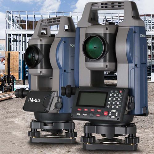
The Sokkia iM 55 Total Station is the perfect entry-level site layout and survey tool offering reliability and flexibility without sacrificing cost or functionality. The Sokkia iM 50 Series Total Station’s sleek design is built tough, with a water and dust-proof IP66 rating, integrated Bluetooth® capability and an internal antenna, enabling you to deliver measurements cable-free to your data controller, streamlining your equipment weight and workflow.
Sokkia iM-55 Reflectorless Total Station is also armed with a top line EDM, generous internal memory storage, and SDRbasic on-board software so you have everything you need to get the job done out in the field.
We are proud to introduce ourselves as one of the major exporting and supplying units of Sokkia Total Station IM 55, based in India. Designed to perfection, the Sokkia Total Station IM 55, provided by us, is required in diverse industries for surveying purposes. Fabricated with the help of high-grade materials, Sokkia Total Station IM 55, available with us, have a sturdy structure and are durable at the same time. Moreover, the clients can avail from us, these quality-tested Sokkia Total Station IM 55 at industry leading prices.
Standard Components
Key Features of Sokkia iM 55 Reflectorless Total Station
Technical Specifications
| Model | Sokkia iM 55 Total Station |
| Telescope | |
| Magnification / Resolving Power | 30x / 2.5″ |
| Length | 171mm |
| Objective aperture | 45mm (48mm for EDM) |
| Image | Erect |
| Field of View | 1°30′ (26m / 1,000m) |
| Minimum focus | 1.3m |
| Reticle illumination | 5 brightness levels |
| Angle Measurement | |
| Display Resolution | 1″/5″ (0.0002 / 0.001gon, 0.005 / 0.02mil) |
| Accuracy (ISO 17123-3:2001) | 5″ |
| Dual Axis Compensator | Working range ±6′ (±111 mgon) |
| Collimation Compensation | On/Off (selectable) |
| Distance Measurement | |
| Laser output (Reflectorless mode) | Class 3R / Prism / sheet mode: class 1 |
| Range reflectorless mode | 0.3 to 500m (1,640ft.) |
| Range prism mode | 1.3 to 4,000m (4.3 to 13,120ft.) |
| Measuring Time | |
| Fine Measurement Mode | 0.9 sec.(Intial 1.5 sec.) |
| Rapid Measurement Mode | 0.6 sec.(Intial 1.3 sec.) |
| Tracking Measurement Mode | 0.4 sec.(Intial 1.3 sec.) |
| Interface and Data Management | |
| Display / Keyboard | Graphic LCD, 192 x 80 dots, backlight, contrast adjustment / alphanumeric keyboard / 28 keys with backlight |
| Control panel location | Single side |
| Data storage (Internal memory) | Approx. 50,000 points |
| Data storage (Plug-in memory device) | USB flash memory (max. 32GB) |
| Interface | Serial RS-232C, USB2.0 (Type A for USB flash memory) |
| Bluetooth modem (optional)* | Bluetooth Class 1.5, Operating range: up to 10m |
| General | |
| Laser pointer | Coaxial red laser using EDM beam |
| Levels Graphic | 6′ (Inner Circle) |
| Circular Level | 10’/2mm |
| Optical | Magnification: 3x Minimum focus: 0.5m from tribrach bottom |
| Dust and water protection | IP66 (IEC 60529:2001) |
| Operatig temperature | -20°C to 60°C |
| Size with handle (w x d x h mm) | 183 x 174 x 348mm |
| Weight with batter and tribrach | Approx. 5.1kg |
| Power Supply | |
| Battery (BDC46C) Detachable battery | Li-ion rechargeable battery |
| Operating time (20°C) BDC46C | Approx. 14 hours (In use of ECO mode. Fine single measurement every 30sec) |


We have available with us a wide range of Vernier Theodolite, which is customized as per the specifications of our clients. Vernier Theodolite is in compliance with various industrial standards. The Vernier Theodolite offers outstanding performance even in rugged conditions. The Vernier Theodolite is widely demanded among surveying and engineering professionals.
Used For
Technical Specifications
| Telescope | Model - 20 | Model - 10 |
|---|---|---|
| Image | Erect | Erect |
| Length | 178 mm | 178 mm |
| Magnificaton | 25X | 25X |
| Effective Aperture | 38mm | 38mm |
| Field of View | 2.6 M at 100M | 2.6 M at 100M |
| Short Focus | 1.5M | 1.5M |
| Stadia Ratio | 0.11 | 0.11 |
| Stadia Constant | 0 | 0 |
| Resolving Power | 4" | 4" |
| Circle Diameter | Hz113mm, V100 mm | Hz113mm, V100 mm |
| Graduation | 20' | 10' |
| Vernier Reading | 20" | 10" |
| - | 45" / 2mm | 45" / 2mm |
| - | 1' / 2mm | 1' / 2mm |

Specifications:

The ET series electronic South Digital Theodolites integrates the same high-quality advanced absolute circle reading technology found in South’s high-performance total station products for more accurate field calculations; and they continue to deliver the highest quality optics and electronics you expect to find in South Digital Theodolites & Total Station, Digital Theodolite South Digital Theodolites, from Roorkee (Uttarakhand).
Technical Specifications
| Specifications | ET – 02 | ET – 05 |
|---|---|---|
| Angle Measurement | ||
| Measuring Method | Absolute Code | - |
| Raster Diameter | 79mm | - |
| Min Display Unit | 1″/5″ Selectable | - |
| Accuracy | 2″ | 5" |
| Horizontal Angle | Dual | - |
| Vertical Angle | Dual | - |
| Telescope | ||
| Image | Erect | - |
| Tube Length | 157mm | - |
| Effective Aperture | 45mm (EDM:50mm) | - |
| Magnification | 30x | - |
| Field of view | 1°30′ | - |
| Minimum Focusing Distance | 1.4m | - |
| Resolving Power | 3″ | - |
| Stadia Ratio | 100 | - |
| Stadia Constant | 0 | - |
| Auto Compensator | ||
| System | Liquid-Electric Detection | - |
| Work Range | ±3′ | - |
| Resolving Power | 1″ | - |
| Vial | ||
| Plate Vial | 30″/2mm | - |
| Circular Vial | 10’/2mm | - |
| Optical Plummet | ||
| Image | Erect | - |
| Magnification | 3x | - |
| Focusing Range | 0.5m~∞ | - |
| Field of View | 5° | - |
| Display | ||
| Type | LCD Display 2 Sides | - |
| On-Board Battery | ||
| Power Supply | Rechargeable Ni-H Battery/AA Battery | - |
| Voltage | DC 6V | - |
| Continuous Operation Time | 10 Hours | - |
| Size & weight | ||
| Dimension | L145xH318xW179 | - |
| Weight | 5.2Kg | - |

We are a prominent Vernier Transit Theodolite, Supplier and Exporter. All models of Vernier Transit Theodolite are made of full brass/gun-metal body having pure silver circles. Our offered Vernier Transit Theodolite is known for its extensive applications. We are offering Vernier Transit Theodolite German pattern at a very competitive price.
Properties:
Other Information
Sample Availability : Yes
Additional Information:
Delivery Time : Immediate
Technical Specifications
| Telescope | Model - 20 | Model - 10 |
|---|---|---|
| Image | Erect | Erect |
| Length | 178 mm | 178 mm |
| Magnificaton | 25X | 25X |
| Effective Aperture | 38mm | 38mm |
| Field of View | 2.6 M at 100M | 2.6 M at 100M |
| Short Focus | 1.5M | 1.5M |
| Stadia Ratio | 0.11 | 0.11 |
| Stadia Constant | 0 | 0 |
| Resolving Power | 4" | 4" |
| Circle Diameter | Hz113mm, V100 mm | Hz113mm, V100 mm |
| Graduation | 20' | 10' |
| Vernier Reading | 20" | 10" |
| - | 45" / 2mm | 45" / 2mm |
| - | 1' / 2mm | 1' / 2mm |

This SETL Digital Theodolite-Electronic Theodolite uses simple structure, and is appreciated for reliable performance. This model of SETL Digital Theodolite is acclaimed for its Independent Laser Light Path, High Stability, Focused Light Point, No Mixed Light and Higher Accuracy. The Laser Plummet is a free feature, provided by this SETL Digital Theodolite. The shipping cost of this SETL Digital Theodolite model is negotiable on extra quantity.
Technical Specifications
| Model | SDJ-02 |
|---|---|
| Telescope | |
| Image | erect |
| Effective aperture | 45mm |
| magnification | 30X |
| field of view | 1o30' |
| Min.focuing distance | 1.3m |
| measuring method | raster |
| Min. reading | 1"/5" |
| accuracy | 2" |
| Display | |
| type | Two-faced LCD , alphanumeric keyboard |
| Auto Vertical Compensator | |
| System | Auto vertical compensation |
| Range | ±3' |
| Optical Plummet ( Optional - Laser Plummet) | |
| Image | erect |
| magnification | 3X |
| field of view | 5o |
| Focusing range | 0.5~ |
| accuracy | ±1mm |
| Power supply | |
| Battery set | rechargeable battery |
| Battery Capacity | 1500mAh |
| Level Sensitivity | |
| plate vial | 30/2mm |
| Round vial | 8'/2mm |
| Laser System ( Optional) | |
| Laser wave lenth | 635mm |
| Laser power | 10nw |
| Working Range | -20oC~+50oC |
| Weight | 5kg |

We are a prominent Geomax Total Station, Exporter and Supplier located in Uttarakhand. We bring forth dimensionally accurate Geomax Total Station, that is known for giving precise results. Geomax Total Station, available with us, is widely used for various applications. Avail Geomax Total Station from us at the industry leading prices.
Specifications:
Technical Specifications
| Description | Required |
| Angle Measurement | |
| Accuracy | 2” |
| Least Count | 1” |
| Angle Method Technology | Absolute Encoder |
| Telescope | |
| Magnification | 30X |
| Objective Aperture | 45mm |
| Image | Erect |
| Field of View | 1deg 30’ |
| Minimum Focus | Less than 2 Meters |
| Distance Measurement range | |
| Single Prism | 3000 M or better |
| Without Reflector (Non-PrismMode) | 250 M |
| Positioning Light | Laser pointer |
| Distance Accuracy with Prism | 2mm+2ppmXD |
| Distance Accuracy without Prism | 3mm+2ppmXD |
| Measuring time | |
| Fine Mode | 2.5 sec |
| Plummet | |
| Plummet | Laser plummet with adjustable brightness |
| Key Board | |
| Display/Keyboard | identical Alphanumeric key Board Both side display with 6 lines with 20 or more keys each side |
| Compensator | Dual Axis Compensation |
| setting Range | + 3’ |
| Clamp Device |
Horizontal & Vertical Drives Lock systems or endless |
| Software on Board | Surveying, Layout, Remote elevation measurement, missing line measurement, Resection, Area, offset. |
| Data Storage: | |
| Internal Memory | Minimum 15,000 blocks with each block consenting of PT, XYZ & code |
| Data Communication | Data transfer through USB cable |
| Power supply | |
| Battery Operating Time | More than 35 hrs for angle mode minimum 9 hrs for distance measurement each battery |
| Charger | Quick battery Charger |
| Environmental condition | |
| Operating Temp | -20deg C to +50 deg C |
| Protection To Dust & Water | IP54 |
| DOWN LOADING SOFTWARE | Should Be Capable Of Downloading/Uploading though USB, Direct Display Of Survey Data In AutoCAD, CSV Format, GIS, TXT etc |
| Accessories with Each unit |
Data downloading cable USB type 1no Battery Charger 1no Battery 2nos Graduated Range pole 2.15 meter with Prism Assembly (Target Plate, Prism & holder)- 2nos Bipod for Pole -1nos Wooden Tripod 1Nos |
| Warranty | One year. |