Company Information
Ask for more detail from the seller
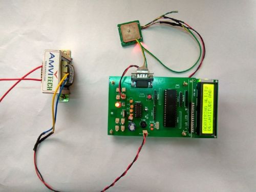
Contact SupplierGlobal Positioning System (GPS) satellites broadcast signals from space that GPS receivers, use to provide three-dimensional location (latitude, longitude, and altitude) plus precise time. GPS receivers provides reliable positioning, navigation, and timing services to worldwide users on a continuous basis in all weather, day and night, anywhere on or near the Earth. This ultra-sensitive GPS receiver can acquire GPS signals from 65 channels of satellites and output position data with high accuracy in extremely challenging environments and under poor signal conditions due to its active antenna and high sensitivity. The GPS receiver’s -160dBm tracking sensitivity allows continuous position coverage in nearly all application environments. The output is serial data of 9600 baud rate which is standard NMEA 0183 v3.0 protocol offering industry standard data messages and a command set for easy interface to mapping software and embedded devices. This project consists of microcontroller, GPS modem and 16X2 LCD. GPS modem takes latitude, longitude and altitude values from satellite and displayed on 16X2 LCD. According to GPS modem position on earth coordinates (latitude, longitude and altitude) will vary from place to place. These coordinates not directly come from satellite, these are in the form of NMEA form. C program extract coordinates from NMEA format and displayed on 16X2 LCD. In this project 7805 is a regulator and it avoids noise spikes in power supply. GPS modem is connected microcontroller through serial port. These GPS modem works under 9600 or 4800 baud rates. 16X2 LCD is connected to microcontroller through digital I/O ports.

Connect with us