-1749191678-8116361.jpeg)

Company Information
Ask for more detail from the seller
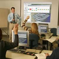
Contact SupplierAdvanced GIS Training: Building Expertise in Geospatial Intelligence Advanced GIS (Geographic Information Systems) Training is a comprehensive, skill-enhancing program designed to deepen participants ' technical knowledge and practical expertise in spatial data analysis, geovisualization, geoprocessing, and geospatial technologies. With the increasing demand for location-based insights across sectors such as urban planning, environmental management, agriculture, disaster response, public health, and infrastructure development, this training plays a pivotal role in preparing professionals and students to meet real-world spatial challenges with accuracy and innovation. Training Objectives The primary goals of Advanced GIS Training are: To equip participants with in-depth knowledge of spatial data structures and advanced analytical tools. To introduce and apply geospatial programming and automation techniques. To enhance capabilities in handling large, complex datasets using both proprietary and open-source GIS platforms. To prepare participants for high-level careers in geospatial science, data analytics, urban development, policy planning, and environmental research. Core Topics and Skills Covered The training typically includes theoretical instruction, hands-on software labs, project work, and real-world case studies. Key modules include: 1. Spatial Data Management Database creation and editing using geodatabases and spatial SQL. Topology rules, spatial joins, and relationship classes. Working with raster and vector data formats effectively. 2. Remote Sensing and Image Analysis Acquisition and preprocessing of satellite imagery. Supervised and unsupervised classification. Change detection and multi-temporal analysis. Use of remote sensing software such as ERDAS Imagine, ENVI, and integration with GIS. 3. Geospatial Analysis and Modeling Surface and terrain analysis (DEM, slope, aspect). Network analysis (route optimization, service area mapping). Hydrological modeling (watershed delineation, flow accumulation). Hotspot analysis, cluster detection, and predictive modeling. 4. Geospatial Programming & Automation Introduction to Python for ArcGIS (ArcPy) and PyQGIS. Automating workflows, building custom geoprocessing tools. Working with APIs, JSON, and web services for dynamic data processing. 5. Web GIS and Cloud-Based Mapping Building interactive web maps using ArcGIS Online, Mapbox, and Leaflet.js. Story Maps and dashboards for public engagement and decision-making. Introduction to GeoServer and PostGIS for enterprise-level data hosting. 6. 3D GIS and Visualization 3D terrain modeling, city modeling, and scenario planning. Tools like ArcGIS Pro 3D Analyst and Scene Viewer. Applications in infrastructure design, environmental planning, and virtual simulations. Software and Tools Used Participants gain proficiency in a variety of GIS platforms, including: ArcGIS Pro / ArcMap (Esri) QGIS (Open Source) ERDAS Imagine / ENVI (Remote Sensing) Google Earth Engine (Cloud-based RS) PostGIS / PostgreSQL (Spatial Databases) Python / R for Geospatial Analysis Capstone Projects and Practical Applications To reinforce learning, participants often undertake real-world projects that involve spatial data acquisition, analysis, and visualization. Examples include: Land use and land cover change detection using satellite data. Mapping urban heat islands and suggesting green cover strategies. Creating flood risk maps using hydrological and topographic data. Site suitability analysis for renewable energy plants. These projects encourage critical thinking, spatial reasoning, and decision-making backed by geospatial intelligence. Outcomes and Career Impact Upon completion, participants are capable of: Designing and managing GIS projects from data collection to final analysis. Developing spatial tools and automating geoprocesses for efficiency. Contributing
-1749191678-8116361.jpeg)


Connect with us
-1749191683-8116370.jpeg)