Listing ID #6586971
Company Information
Ask for more detail from the seller
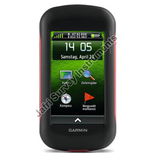
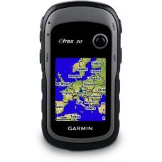
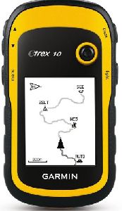
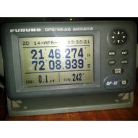
Contact SupplierGarmin Montana 680 features a dual-orientation, color touchscreen that’s glove friendly and includes a 1-year BirdsEye Satellite Imagery subscription. The digital camera provides high-quality images, excellent resolution and automatically geotags photos with coordinates.
Key Features of Garmin Montana 680 Touchscreen Mapping Handheld GPS
Rugged GPS/GLONASS with 8 Megapixel Camera and BirdsEye Subscription
Take it hiking. Take it hunting. Take it on the water.
Garmin Montana 680 features a dual-orientation, color touchscreen that’s glove friendly and includes a 1-year BirdsEye Satellite Imagery subscription. The digital camera provides high-quality images, excellent resolution and automatically geotags photos with coordinates.
Handheld includes 3-axis tilt-compensated compass, barometric altimeter and access to both GPS and GLONASS satellites for improved positioning and typically faster fixes.
Enjoy the View
Montana 680 has a vast 4-inch, sunlight-readable touchscreen display, giving you vivid colors and high-resolution images. Its easy-to-use touchscreen means you’ll spend more time enjoying the outdoors and less time searching for information.
Take Geotagged Pictures
Capture locations and memories with Montana 680’s 8 megapixel digital camera. Each photo is automatically geotagged with coordinates, allowing you to navigate back to that exact spot in the future. Keep track of your photos and see their locations on a map using BaseCamp™. Insert a microSD™ card for more photo storage or to view pictures from other devices.
Mount Anywhere
With an array of compatible mounts, Garmin Montana 680 is designed for use on ATVs, in boats, as a handheld or in your car or RV. Use the auto mount with City Navigator® NT maps for spoken, turn-by-turn driving directions or the rugged mount for your motorcycle or ATV.
Go Everywhere
Adding more maps to Montana is easy. Download TOPO U.S. 24K maps and hit the trail, plug in BlueChart® g2 preloaded cards for a day on the water or load City Navigator map data for turn-by-turn driving directions. Add satellite images to your maps with BirdsEye Satellite Imagery (1-year subscription included). Or, transform paper maps into files you can download to your Montana with Custom Maps.
Share Wirelessly
With Montana 680, you can share your waypoints, tracks, routes and geocaches wirelessly with other compatible Garmin GPS users. Just press “send” to transfer your information to similar devices and let the games begin.
Keep Your Fix
With its high-sensitivity GPS and GLONASS reception, WAAS-enabled receiver and HotFix® satellite prediction, Garmin Montana 680 locates your position quickly and precisely and maintains it. Whether you’re in deep woods or just near tall buildings and trees, you can count on Montana 680.
Navigate with Ease
Montana 680 has a built-in 3-axis tilt-compensated electronic compass, which shows your heading even while you’re on the move or not holding it level. The barometric altimeter tracks changes in pressure to pinpoint your precise altitude, or use it to plot barometric pressure over time to help keep an eye on changing weather conditions.
Double Your Power
With a one-of-a-kind dual battery system, the Montana 680 gives you the option of using the rechargeable lithium-ion pack or traditional AA batteries.
Find Fun
Garmin Montana 680 supports paperless geocaching GPX files for straight-to-device uploading of geocaches from Geocaching.com. No more manually entering coordinates and paper print outs, Montana stores and displays key information, including location, terrain, difficulty, hints and descriptions. The track manager feature helps organize and navigate through waypoints/routes/ and track logs (easily start/stop recording tracklogs).
Plan Your Next Trip
Our free BaseCamp software lets you view and organize maps, waypoints, routes and tracks. This free trip-planning software even allows you to create Garmin Adventures that you can share with friends, family or fellow explorers. BaseCamp displays topographic map data in 2-D or 3-D on your computer screen, including contour lines and elevation profiles.
Garmin Montana 680 – Scope of Delivery
| Physical dimensions | 2.9″ x 5.7″ x 1.4″ (7.48 x 14.42 x 3.64 cm) |
|---|---|
| Display size, WxH | 2″W x 3.5″H (5.06 x 8.93 cm); 4″ diag (10.2 cm) |
| Display resolution, WxH | 272 x 480 pixels |
| Display type | bright, transflective 65k color TFT, dual-orientation touchscreen, sunlight readable |
| Touchscreen | yes |
| Weight | 10.2 oz (289 g) with included lithium-ion battery pack; 11.7 oz (333 g) with 3 AA batteries (not included) |
| Batteries | rechargeable lithium-ion (included) or 3 AA batteries (not included); NiMH or Lithium recommended |
| Battery life | up to 16 hours (lithium-ion); up to 22 hours (AA batteries) |
| Water rating | IPX7 |
| High-sensitivity receiver | yes |
| Interface | high-speed USB and NMEA 0183 compatible |
| Camera | yes (8 megapixel with autofocus; automatic geo-tagging) |
| Barometric altimeter | yes |
| Electronic compass | yes (tilt-compensated 3-axis) |
| Unit-to-unit transfer (shares data wirelessly with similar units) | Yes |
| Basemap | yes |
|---|---|
| Ability to add maps | yes |
| Built-in memory | 4 GB |
| Accepts data cards | yes, microSD™ card (not included) |
| Custom POIs (ability to add additional points of interest) | yes |
| Waypoints/favorites/locations | 4000 |
| Routes | 200 |
| Track log | 10,000 points, 200 saved tracks |
| Automatic routing (turn by turn routing on roads) | Yes (with optional mapping for detailed roads) |
|---|---|
| Geocaching-friendly | yes (Paperless) |
| Custom maps compatible | yes |
| Hunt/fish calendar | yes |
| Sun and moon information | yes |
| Tide tables | yes (with optional Bluechart) |
| Area calculation | yes |
| Picture viewer | yes |
| Garmin Connect™ compatible (online community where you analyze, categorize and share data) | yes |
| Garmin Connect™ compatible (online community where you analyze, categorize and share data) | yes |
| Warranty | One Year Warranty. |

Connect with us