Listing ID #6038242
Company Information
Ask for more detail from the seller
Contact Supplier
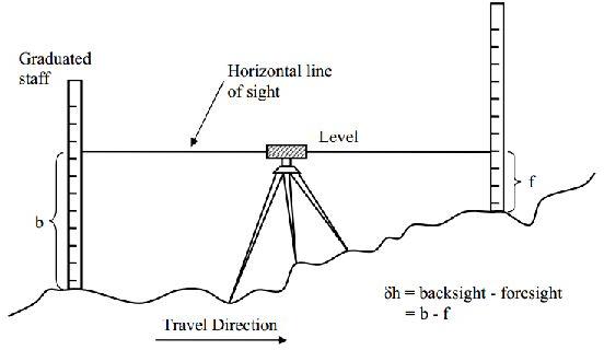
A Ground Level Survey, also known as a ground survey or ground leveling survey, is a specialized type of land survey conducted to precisely determine and document the elevations and contours of the ground surface in a specific area. This survey provides crucial information about the topography of the land, helping in various applications such as construction, engineering, landscape design, and environmental planning.
Key aspects of a Ground Level Survey include:
Elevation Measurement: Surveyors use precise instruments to measure the elevation of multiple points on the ground, creating a detailed representation of the land's surface.
Contour Mapping: The survey involves the creation of contour lines, connecting points of equal elevation, to illustrate the shape and variations in the terrain. Contour maps provide a visual representation of slopes, hills, valleys, and other land features.
Topographic Detail: The survey captures information about natural and man-made features on the ground, including bodies of water, vegetation, buildings, and other landmarks.
Geodetic Control: Establishing accurate geodetic control points to ensure consistency in measurements and align the survey with broader geospatial frameworks.
Mapping and Documentation: The collected data is processed and used to generate detailed maps or digital models of the surveyed area, providing a comprehensive understanding of the land's topography.
Construction Planning: Ground level surveys are essential for construction projects as they help architects, engineers, and builders plan the layout of structures, roads, utilities, and other elements in accordance with the natural contours of the land.
Drainage and Grading: The survey provides valuable information for designing effective drainage systems and grading plans to manage water runoff and prevent issues like flooding.
Environmental Impact Assessment: Ground level surveys contribute to environmental studies by providing data on the existing terrain, which is crucial for assessing the potential impact of development on the natural landscape.
Land Use Planning: Planners use ground level survey data to make informed decisions about land use, zoning regulations, and the suitability of areas for various purposes.
Infrastructure Development: The information from ground level surveys supports the planning and development of infrastructure projects, ensuring that construction aligns with the existing topography.
Ground level surveys play a foundational role in many aspects of land development and resource management. The accurate representation of the land's surface is vital for making informed decisions that contribute to sustainable and effective land use.
Established in the year 2016, we, Lucknow Land Surveyors, are one of the most reputed organizations engaged in proposing reliable and effective Construction and Engineering Survey Services and we also provide service for coordinate verification. We are the registered agent for AAI height clearance. Our offered services are operative and are performed within the stated period with the help of expert & proficient professionals. To keep their reliability and efficiency, we apply the latest methodologies, equipment and higher quality accessories in rendering these services.
We are on the path of constant success and growth under the leadership of our mentor and guide, Mr Umesh Yadav \', our owner who holds huge experience in this field. His outstanding entrepreneurship and guiding skills have helped us in accomplishing our organizational goals.
The services offered by us are
Land Surveying service
Canal surveying service
Topographic Survey Services
Building surveyor survey service
Electric line survey service
Railway track survey service
Soil testing service
And many more in this category
Our strength
With the support of the latest equipment’s and experienced professionals, we bring these services in a prompt, proficient and streamlined manner. Our offered services are under the client’s necessities and international standards of quality:
Why us?
Providing an extensive range of survey services
Excellent team of experts
Equipped with the latest technology
Experienced in many sectors


Connect with us
