Company Information
Ask for more detail from the seller
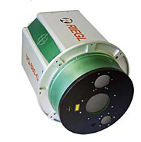
Contact SupplierThe RIEGL VQ-880-G carries out laser range measurements for high resolution surveying of underwater topography with a narrow, visible green laser beam, emitted from a powerful pulsed laser source. Subject to clarity, at this particular wavelength, the laser beam penetrates water enabling measurement of submerged targets.
The RIEGL VQ-880-G comprises a high precision inertial measurement sensor for subsequent precise estimation of the instrument's exact location and orientation. A high-resolution digital camera and optionally a additional infrared laser scanner are integrated to supplement the data gained by the green laser scanner. The rugged internal mechanical structure together with the dust- and splash water proof housing enables long-term operation on airborne platforms.Designed for combined topographic and hydrographic airborne survey
High accuracy ranging based on echo digitization and online waveform processing with multiple-target capability
Multiple-time-around processing for straightforward mission planning and operation
Concurrent full waveform output for all measurements for subsequent full waveform analysis
High spatial resolution due to measurement rate of up to 550 kHz and high scanning speed of up to 160 scanssec
Integrated inertial navigation system
Additional, fully integrated infrared laser scanner (optional)
Integrated digital camera(s)
Compact and robust housing compliant with typical hatches in aircrafts and with stabilized platforms

Connect with us