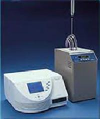
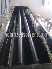
We are a well known Manufacturer and Supplier of Map Dispensing System . The system delivers flawless performance and high productivity. detail : The maps printed on polyurethane sheets are rolled on motorized pipes stacked in fixed positions in such a way that on giving command more...
Global Regulatory requirements are very dynamic and becoming stringent with respect to the development, manufacturing, and distribution of biopharmaceutical products. Given the dynamic nature of regulations, medicinal products’ manufacturers are facing challenges in decodinmore...
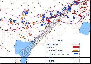
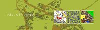
If you are looking for contour Mapping Services, you are in the right place. Our company Zodiac Infosolec is the best for these services. A line on the map shows the value of the parameter that is being mapped. This line also includes the points that have equal value and that sepmore...
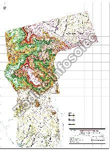
Zodiac Infosolec is well known for its Topographic mapping services in West Bengal, India. These mapping services are used to identify and also to map the contours along with existing features on the earth's surface. This is extremely beneficial for the industries like emery sectmore...
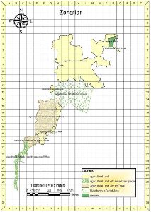
Zodiac Infosolec has made a huge name in the market as the best Revenue plot Mapping service in West Bengal, India. Revenue Plot Mapping is the process that which lands parcels are made for effective and efficient land management. This mapping service generates the maps that are more...
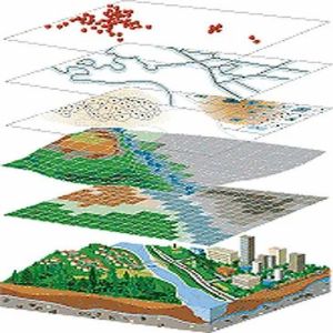
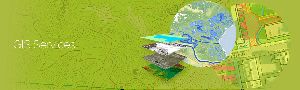
A geographic information system (GIS) is a computer system for capturing, storing, checking, and displaying data related to positions on Earth’s surface. GIS can show many different kinds of data on one map, such as streets, buildings, and roads. This enables people to moremore...
Studies show that having a ready pipeline of top quality candidates in place (before you need it) helps to improve quality, speed and cost per hire. Defining your competitive landscape and candidate profile ahead of time will allow you to connect with inactive job seekers. It movmore...
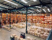
Owing to our domain expertise, we are offering our clients temperature and RH mapping services for Large Warehouses/Chambers/Cold rooms/Walk-in chambers/Cold Storages, etc. The offered service includes temperature and relative humidity mapping/thermal qualification assessing the more...
Owing to our domain expertise, we are offering our clients temperature and RH mapping services for Large Warehouses. The offered service includes temperature and relative humidity mapping/thermal qualification assessing the area for compliance with required storage conditions. Inmore...
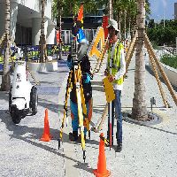
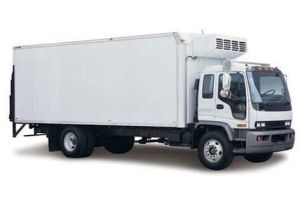
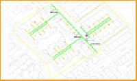
We provide Temperature Mapping service for all kind of Reefer vehicles with all range of vehicle sizes . Mapping is done as per standard protocol and customer requirements for multiple temperature range as specified. We use NABL certified data logger sensors to give highly accuramore...
we are a gis and planning based consultancy & software development based in rajasthan since 2015, offering quality services and solutions to customers globally. we specializes in geospatial services, planning & dpr expert, gis surveys, contour mapping, cadastral and parcel mapmore...
Our vector maps are provided as high-quality, scalable vector format files. Our digital map vector files are available in a number of different projections, which affords you greater flexibility in finding a map that matches your design goals and requirements. which range in detamore...
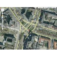
Our Route Mapping and Surveys Service provides meticulous analysis and planning for optimized transportation routes. Using cutting-edge technology and expertise, we conduct thorough surveys to identify the most efficient paths for your logistics operations. From assessing more...
trackopath is a fast-growing firm engaged in the areas of civil engineering and project management consulting services in various sectors like highways, bridges, urban and regional planning and buildings. more...
We provide technologically advanced Map Dispensing System that is widely used in industrial applications. Our Map Dispensing System is integrated with the advance features that ensure high performance. Further, we can provide Map Dispensing System in different specifications to mmore...
We understand it is difficult to maintain/track the updated data at a regular interval. Simultaneously we understand it's important so we help clients to get the updated data collections and mapping and provide them with the proper documentation. more...
Drone Site Surveys uses technology to offer construction professionals alternative visual options, enabling them to work smarter. Drones offer us safer a.tyernatives to external work and working at height. Drone Site Surveys has drones for every task, whether you require highlmore...
This study is done by using all advanced resourcing techniques to support our clients know about the talent available in targeted departments, prevailing compensation, designations and trends being followed by its competitors. more...
We are providing temperature mapping services. From the smallest bench top oven, to the largest sterilizer, (and everything in between), qatech can put a package in place which will not only meet your validation requirements, but exceed your expectations!! rnrnif you already havemore...
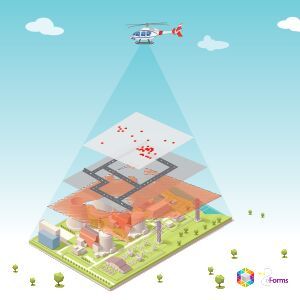
GIS Mapping Company in India, GIS (Geographical Information System) Companies in India, GIS Mapping for Smart City . Our Company is the best in GIS Analysis |GIS Mapping Companies in Delhi. GIS Mapping services company | Carbon Stock Estimation/Calculation |GIS Mapping | gis more...
The requirement for accurate and reliable positioning is not restricted to survey. Today, distinctive business sectors including power grids, oil and gas, utilities, water, and area administration projects induce mapping services that give decimeter or better precision. more...
Topographic mapping services helps in route planning, thematic data preparation, and decision-making for telecom and transport services and disaster management. The 3D topographic maps cover an area of approximately thousands of square kilometres and therefor require experienced more...
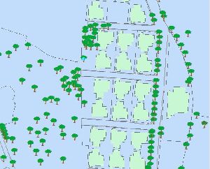
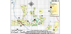
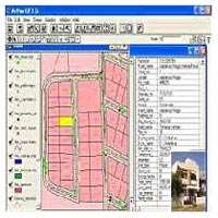
Cadastral mapping is a comprehensive register of the details related to the property of an area. These details include the precise location, dimensions, and other geographical classifications of the properties or individual parcels of land. The maps generated using cadastral mappmore...
Indoor building maps operates on the basic fundamentals of calculated path mapping a sophisticated system allows the user to find the shortest route between their origin and destination in real time, depending on sources of user input. more...
Are you looking for watershed mapping services? At Ecobasics, Mumbai you will get the best services at an affordable price. We are known all around the nation for our professional services and competitive pricing. We have consultants and professionals with amazing skills and talemore...
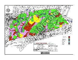
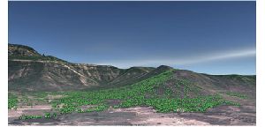
A vegetation mapping means the data which is essential for the comprehensive land use and forestry planning. Measuring the current vegetation condition can help achieve the vegetation classification maps. Ecobasics is one of the reputed and reliable company in Mumbai. We provide more...
Terrain mapping can help your business to turn simple raw footage or aerial data into actionable business intelligence. From monitoring to inspecting miles of pipelines, Ecobasics provide the best terrain mapping services to the customers and clients. We identify the issues whichmore...
A noise map is normally generated using computer software that calculates noise levels from input data such as traffic flows and topography (e.g. ground levels) Computer modeling is used rather than noise measurement as measurement would be prohibitively expensive and it would bemore...
Three-dimensional models of urban environments are useful in a variety of applications. They are typically represented either as Digital Surface Models (DSM) or triangular 3D meshes. A standard technique for obtaining the geometry of a large-scale city area in an automated or semmore...
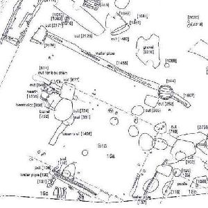
We are offering parcel/cadastral/mapping. Parcel maps facilitate administration, zoning, flood determination, real estate, service territories, financial services, tax, utilities, building and site development, lake and stream erosion control, planning, design and construction ofmore...
Major investments need to be made in society’s utility supply lines; water mains, sewage systems, telephone lines, power lines, gas mains, etc. Often the geographic location is recorded on inferior quality maps and in some cases it is not documented at all. Certainty of supply,more...
We hold expertise in providing highly effectual Utility GIS Mapping Service. Our Utility GIS Mapping Service is inclusive of image procurement & processing, land base creation, asset survey/ coding, consumer survey/ indexing, deliverables in personal geo-database format and develmore...
We are Service Provider of Cadastral Mapping . Cadastral Mapping, that we offer, comprises scanning, digitization, mosaic and geo-referencing of original village cadastral/ revenue maps on village/ tehsil/ district/ state level and development of a detailed land information systemore...
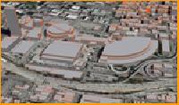
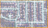
We are the one stop shop for availing excellent Digital City Mapping Service. Professionals providing Digital City Mapping Service are engaged in image procurement, processing & geo-referencing, interpretation & feature extraction, unique id generation and output deliverables in more...
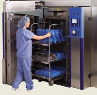
We Digiqual Systems do Thermal Mapping Calibrations using our Data Logger Using Suitable Temperature Sensors according to the application. Mapping Duration 12 24 48 Hrs. Mapping Areas – Ovens, Furnaces , Stability Chamber, Cold Rooms, Deep Freezer, Medical Ware House e.t.c We pmore...
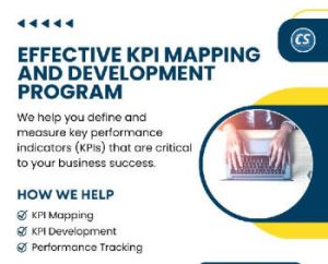
At Corporate Stalwarts, we understand that key performance indicators (KPIs) are critical to the success of any organization. That's why we offer our KPI Mapping & Development service to help you identify, develop and monitor your organization's KPIs. Our KPI Mapping & Developmenmore...
Corporate Stalwarts' Competency Mapping service is designed to help your organization identify and develop the key competencies required for success in your industry. With Corporate Stalwarts' Competency Mapping service, you can be confident that your organization has the compmore...
We are actively engaged in providing GIS mapping to the customers. The services that we render assist the customers to create contour maps, spatial maps, atlas maps, cadastral maps, etc. The services include utility mapping, tax parcel mapping i.e. preparing data for computer-assmore...
we are providing cadastral mapping services. geo adithya can receive the inputs of various domains such as cadastral maps, utility maps, geology maps and engineering or architectural drawing in paper or a scanned image format. geo adithya will digitizeconvert these maps to digitamore...
Geo adithya has provided photo grammetric solutions with technically skilled team in chennai & across india. A lot of changes have occurred since this time and we have been a key driver of new technology. Our derived products go through a barrage of quality control procedures desmore...
Demographic mapping helps you accomplish prospective customer and is in co-relation to lifestyle info graphics. It is an effective approach to focus on your customer’s requirements. more...
This market map illustrates the range of positions that a product can take in a market based on two dimensions that are important to customers. more...
Thermography mapping has evolved as one of the quickest and most-efficient for analysis of insulation degradation, boiler application, and electronic components. Based in Kutch, we at Marinetech Safety and Shipping Corporation, we offer the safest thermography mapping services thmore...
We are a well-known Service Provider. We are engaged in undertaking various kinds of Mapping Services, such as Mapping Services Cadastral Mapping, Digital City Mapping and Utility GIS Mapping. Mapping Services are provided by our experienced team that is highly knowledgeable and more...
We are the one stop shop for availing excellent Digital City Mapping Service. Professionals providing Digital City Mapping Service are engaged in image procurement, processing & geo-referencing, interpretation & feature extraction, unique id generation and output deliverables in more...
We are Service Provider of Cadastral Mapping. Cadastral Mapping, that we offer, comprises scanning, digitization, mosaic and geo-referencing of original village cadastral revenue maps on village tehsil district state level and development of a detailed land information system. more...