Our Route Mapping and Surveys Service provides meticulous analysis and planning for optimized transportation routes. Using cutting-edge technology and expertise, we conduct thorough surveys to identify the most efficient paths for your...
Our Vessel Survey Service offers comprehensive inspections and assessments to ensure the seaworthiness and compliance of maritime vessels. With certified marine surveyors and advanced inspection techniques, we conduct thorough examinations of hulls,...
Cargo and Container Survey Services ensure the safety, quality, and compliance of goods during transit. These services involve inspecting cargo conditions, verifying container integrity, checking seals, and documenting damages or discrepancies. They...
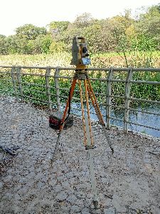
Survey Process : Hydrographic Surveying: Measuring Water Depth And Preparing Bathymetric Maps.,Boundary Demarcation: Identifying Legal Limits Of Ponds And Lakes To Prevent Encroach,Topographic & Contour Mapping: Documenting Surrounding Terrain For Watershed Planning And F
Layout Designing Survey – Accurate Planning for Residential, Commercial & Industrial Projects A Layout Designing Survey is an essential step in the planning and development of residential, commercial, and industrial projects. It...
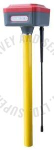
DGPS Surveyor – Precision Land Surveying with Sub-Meter Accuracy A DGPS surveyor specializes in conducting land and infrastructure surveys using Differential Global Positioning System (DGPS) technology. DGPS enhances the accuracy...
Our GIS & CAD Survey Service provides accurate, data-driven mapping and drafting solutions for engineering, planning and land development projects. We combine advanced GIS technologies with precise CAD drafting to deliver detailed site maps,...