Based in Rajasthan, HRD Groups is the prominent Land Surveying Services Provider. The company functions with the help of expert professionals who are seasoned in providing Land Surveying Services with full dedication and passion to fulfil the...
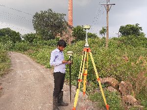
Quantity Surveying by TS" most likely refers to using a Total Station (TS) , DGPS AND DRONE a modern surveying instrument, for quantity surveying tasks, which involves using the TS for site surveys to gather data like distances and...
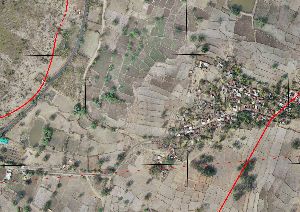
A drone survey uses unmanned aerial vehicles (UAVs) equipped with sensors like cameras and LiDAR to capture data from above, creating high-resolution maps, 3D models, and other geospatial information. This method is faster, more...
Existing Surveyor – Accurate Documentation of Developed Sites An Existing Surveyor specializes in conducting surveys of already developed or partially developed land, buildings, and infrastructure. Unlike preliminary land surveys, an...
A Quantity Surveyor specializes in cost estimation, project budgeting, and financial management for construction projects. They ensure accurate material take-offs, tendering, and cost control, helping developers, contractors, and clients deliver...
Marine Surveyor inspects ships, boats, and marine equipment to ensure safety, seaworthiness, and regulatory compliance. They assess vessel condition, cargo handling, and maintenance, providing detailed reports, certifications, and recommendations...
Water Body Surveyor – Accurate Surveying & Mapping of Water Resources A Water Body Surveyor specializes in surveying and mapping natural and man-made water bodies such as rivers, lakes, ponds, reservoirs, wetlands, and canals. These...
Hoist inspection services are crucial for ensuring the safety and functionality of lifting equipment. These services involve rigorous examination and testing of hoists, including wire ropes, hooks, and controls, to identify any defects or wear that...
Zodiac Infosolec is the best for DGPS Survey Services in India. This survey is used for the improved location accuracy, in the range of operations of each system, these surveys are constantly correct to the sub-centimetre level. Each DGPS...
We have gather vast experience in drone survey this survey system can provide more precise survey data with a minimum cost. Processing all the acquired images took only a few hours, generating complete Arial Image of the entire region. These...
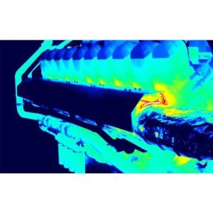
Our Thermal Analysis Service employs sophisticated tools to assess and optimize thermal performance in engineering systems. Utilizing advanced software, we simulate heat transfer, thermal stresses, and temperature distribution within components or...